Sunday, December 6, 2020

Black Hill, Ephraim

 I'll say right up front this area is not nearly as favorable as the White Hill several miles north... We have ridden here twice and are not going back.  Why? Steep, rocky areas and slippery slopes of shale.  Why here when White Hill is so much better and not nearly as crowded.

It's close to Ephraim (a college town) so has much more traffic.  We were there on a Saturday, December 5 for a short ride and ran into several people target shooting.  While we were on the hill, a bullet ricocheted off a rock and sailed right over us.  We had to yell at the people and tell them "Hold up.  Horses up here!" Lots of litter, broken bottles, beer cans, spent shotgun shells, etc. lying about.  What IS wrong with people!?


To reach the parking area, travel east on 100 N. in Ephraim.  Once you reach the gravel road, go 1.5 miles.  

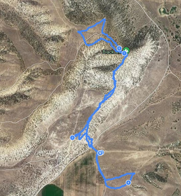
This was our track for the day. About 4.5 miles.

A map from one of the biking sites.

This is looking at the parking area from up on the ridge.


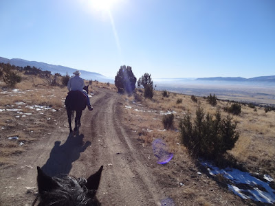
There are some expansive views of Sanpete Valley both north and south.

You'll ride around and through lots of juniper.  

This "monument" was on top of the Black Hill.  So sad that people leave their trash.  Mozzy thought it was a really strange looking thing...

If you have a barefoot horse, the rocky trails will help trim down those hooves.  Our barefoot horses had no problem plowing through the rocks.  Much rockier than White Hill.


More of people's trash.


All in all, it was nice to see what was here.


(Update, we rode here on May 23, 2022.  Monday morning and no one else was around.  The photos below are of this ride. Didn't get any of the really rocky and steep areas.)

3.5 miles total.


Apparently this is an attempt to plant shrubs for the wildlife feeding.  10,000 seedlings.

One of the nicer parts of road.

Looked like an ancient stone road leading up to a small quarry area.


Tuesday, November 3, 2020

Fish Lake


This was our first riding trip to Fish Lake.  We reconned the area on Nov. 1 and discovered the conditions seemed ideal for a ride.  No crowds.  In fact, basically no one else at all. And very little snow that we could see and dry trails.    We decided at the last minute that Nov. 2 would be our only chance to ride it this coming week, so we packed up and made a day trip.  I had studied maps, so had an idea of what we wanted to do. 
 But, studying maps may help a little, but doesn't prepare you for the trail conditions, steepness or distance.  I found out shortly before we went that the Lakeside trail we wanted to ride was off limits to horses for a considerable part. My next plan was to park in a pull out near the Pelican Point, ride the Lake Shore trail to the other trailhead, then ride down the trail along the southeast side of the lake until we got to the part that went up the mountainside. It looked to be about a 7-8 mile ride.   

Here is a link to a description of the 4 sections of the Lake Shore National Recreation Trail.  https://www.fs.usda.gov/recarea/fishlake/recarea/?recid=80504

We ended up riding part of Section 3.

This map at the trailhead was misleading.  Made it look so easy.  Glad I studied more detailed maps.


This portion of a topo PDF map was more helpful.  I studied it, but didn't take it with me.


This view from the trailhead looked good.


Yep, horses allowed.

This is where we ended up parking.  Across the road to the northwest from the Lake Creek trailhead.  Lots of horse evidence here.

This is the actual trailhead called "Lake Creek".  We could have parked here.


This was our track for the day.  7 miles total.  We rode part of the LakeShore trail, went a little ways up the Crater Lake Trail, crossed over to the Porcupine Draw trail, went up towards Johnson Valley Reservoir on the Lake Creek trail and then back to the trailhead, our trailer, then took a cross country ride up the ridge before quitting for the day.  We kept saying "We better do this, because we may not come back here."  Now, thinking back on it, I wouldn't mind coming back, perhaps a bit earlier in the year, maybe October when the aspen leaves were still on.  I would NOT do the Section 3 of the Lakeside trail again.  We only got half way down and turned around because we were just tired of the rocky trail. We were able to avoid some of it by riding closer to the shore line.  I was hoping maybe for a beach, but it was just too muddy and looked unsafe.


Started out by crossing the road and getting from our parking spot to the trailhead.

A bridge right off the bat.  On the way back we found a nice place to cross and give the horses a drink.


Riding along the Lake Creek trail

Lake Creek Trail looking towards Johnson Valley Reservoir

Porcupine Draw trail looking towards Lake Creek

Heading up the Crater Lakes trail right at first. We were hoping for a view shot from the top of the ridge, but ended up not getting it because we went down another way.


This is where we turned back on the Crater Lakes trail.  It just got too rocky and steep.  The photo doesn't show how steep at all!

Pretty spot on the Crater Lakes trail


Lake Side trail Section 3

Lake Side trail Section 3

Lake Side trail Section 3

Lake Side trail Section 3

Lake Side trail Section 3


We didn't ride out on Section 2, but chose instead to just ride up the hillside a little bit to get a lake view.
All in all, the solitude was refreshing and the views were wonderful. It was really nice to ride with no noise or crowds or flies or mosquitoes.
 It was worth the 5 hours of total driving time...we might be back again to do Section 2 of the Lakeside and maybe one called Reflection Spring.
I'll update  the blog if we do.
Meanwhile, if anyone has more information or photos on the trails around Fish Lake, let me know.


I found the following map AFTER we got back.


Saturday, October 31, 2020

Spring City (White Hill) Wildlife Management (WMA)


(Updated April 13, 2024) When the upper trails are mostly muddy and snowy, this Wildlife Management Area (WMA) near us is a good choice. As of April, 2024, there are some great horse trails here, well marked with signs. The trails are all suitable for barefoot horses in reasonably good condition.  A few somewhat rocky/gravelly spots, but mostly soft sandy dirt. It pays to study a map first and get an idea of where to ride.  Please stay off the bike/hike only trails. All in all an enjoyable ride.  Very dry and no water feature.  Would not recommend in the summer heat.  Definitely a late fall or spring ride.  (as always, click on a photo to open larger images.) 


Reference map of trails https://www.trailforks.com/trails/the-master-loop-mtn-bike-trail/. (some of the map information is not completely correct or complete, but it's one reference.)


Parking

UPDATE!  The parking has been expanded and gated off.(locked access for motorized vehicles Dec. 1-April 15.)  Thank you Back Country Horsemen of Central Utah! This shows the new parking area as of April 19, 2023.

View from the parking area on May 4, 2023.


Tracks

May 13, 2024--interesting 4.8 mile ride--basically down the North Badger trail, the complete Bitterbrush and then on down to the West Jack Rabbit.  Our intention was to find the Far West Jack Rabbit, which we eventually did, but it was very faint in places and we missed the turn up.  We ended up south of the Rattlesnake just bushwhacking, then came to the East Jack Rabbit and on back.


May 2, 2024 track.  3.1 miles.  Nice short ride.  The red line is a new trail for us--Rattlesnake.  I hope that name is a mis-nomer!   It branched off of the south-west Jack Rabbit. No photos yet.  It is an option to come off the ridge down to Pigeon Hollow trail.  It is basically riding through juniper forest--no views.  A little rocky in spots.


  April 25, 2024. 3.3 mile, nice short loop for barefoot horses. Included Bitterbrush and Jack Rabbit trails..
 

Our track on April 19, 2024--(the red line--we didn't get a GPS track. This is approximate). A nice 4.2 mile loop.  Parts of Badger, Elk Horn, Sego lily, Bitterbrush, Eagle, Jack Rabbit & Pigeon Hollow.


Our track on November, 13, 2023, which included the Eagle Trail shown in Yellow. 2.5 miles total coming back on the Jack Rabbit and Pigeon Hollow.

 April 19, 2023. We stayed on the roads and visited the south quarry--About 3.8 miles.


Track on November 1, 2023


All "Horse Trails" ride on May 4, 2023.  Starting out counter-clockwise at the top (coded in MAGENTA sprinkles) is what is now called Elk Horn Trail.  It joins what I call the North Quarry Road (coded in SEA FOAM GREEN. ) We rode this road west and curved back east on the South Quarry Road.(coded in TEAL) There was plenty of room to ride in the grass on the side of this road until we intersected the Quarry Hills which is for bikes only.  Photos below of what to watch for.  We were pointed out the horse trail with the tentative name of Sego Lily. (coded in STRAWBERRY RED).  We went UP this kind of steep hill and intersected Keslo Loop Road. (coded in HONEYDEW--LIGHT GREEN). We rode this up a few dozen yards until we spotted some trails leading south.  We wound our way through the trees, staying away from the bike trails and eventually found what I call the Pigeon Hollow Ridge Road  and Jack Rabbit and Pigeon Hollow trails (available for horses and bikes.). That brought us back to the parking area. 5 mile Loop.  Highest point 6,120'.  Ascent=1,014'.  Trail conditions:  70% dirt, 15% gravelly and 15% rocky.  Fine for barefoot horses in good condition.

  April 20, 2022.  Basically, just rode from one road to the other.  Photos below of that ride. We call this route "North Quarry". The top part of the "lollipop" is now called the Badger trail.

 Oct. 31, 2020.   About 7.2 miles.  We made some incorrect turns and ended up WAY too far west, which required us to do some bushwhacking and zig zagging down a steep hill to get back down to the road.  I used my phone to toggle back and forth which showed kind of where we should have gone.  Oh, well, it was still a good ride and there is so much left to explore.  It kind of reminds me of Antelope Island without the lake. 😊
The part we rode was mostly dirt, some soft and some hard; many rocky areas, but nothing a barefoot horse in good condition cannot handle.  Some two tracks and some single tracks and some no tracks.  We didn't see anyone else even though it was a Saturday.  We saw bike tracks, OHV tracks and horse tracks. (This track did not involve any of the "MASTER LOOP"--Now called "Quarry Hills")

Trails—Jack Rabbit/Eagle

 Jack Rabbit, April 25, 2024, heading west

West Jack Rabbit, April 25, 2024--where it intersects with the bike trail.


View from South Eagle trail (which has great views of both valleys), April 19, 2024

West Jack Rabbit, April 25, 2024


Sign for Jack Rabbit from the ridge going west.

Far West Jack Rabbit, May 13, 2024

Trails—Sego Lily/Bitterbrush

Bitterbrush trail, April 19, 2024
May 4, 2023, Here is the beginning of what is tentatively called Sego Lily Trail.  It is faint and veers off to the left from the well worn bike trail.

Should be looking like this. May 4, 2023 


...And this.  Trail can also be accessed from the south quarry here.

Sego Lily Trail, May 12, 2023


"Top" of the Bitterbrush trail.  At this point you can either turn west for the Jack Rabbit, or...east up the road to the Eagle trail.


Trails—Pigeon Hollow


May 12, 2021.  Lots of sheep in the meadow on the Pigeon Hollow. Can avoid by staying on the upper trails. (As of 2023, I don't believe sheep are allowed there anymore.)

"Fork" where the Pigeon Hollow trail splits up with the horse trail going to the left (South Loop) and the bike trail to the right.  Taken November 1, 2023.


Pigeon Hollow--Lower South Loop Trail on November 1, 2023--not much traffic on this one


April 19, 2024, headed back to parking on the Pigeon Hollow


Trails—Elk Horn/Badger


View from the Elk Horn as it heads down the hill on the west side of the north quarry.


Further down from the Elk Horn as it heads down the hill on the west side of the north quarry.


Where the Elk Horn intersects with the North Quarry Road
. At this point turn right for one option.  Turn left for another option and ride up the road for about a half mile.  There, a new trail called the Bitter Brush takes off up the hillside. (that ends up being a "short cut".)  Yet, still ANOTHER option is to ride across the road for the continuation of the Elk Horn.  As of our ride on April 19, 2024, it is marked with yellow/blue ribbons and connects over the hillside to the South Quarry Road.

South Badger Trail, April 19, 2024


Roads

Photo above shows the "south quarry", April 19, 2023.


Heading west on the North Quarry Road. There is a corral of sorts.  You can ride to the left of it cross country to avoid the road if desired.  But, the road is soft dirt...


Turned back east on the South Quarry Road.

You don't have to ride ON the South Quarry road.  Plenty of room in the valley bottom.


April 7, 2022, view of Mt. Nebo. This is the North Quarry Road.

April 7, 2022, the "Ridge Road" which goes up between the North and South quarry roads.


On the North Quarry road almost to HWY 89.


Photo taken on April 19, 2023.  Part of the road coming in from HWY 89 to the south quarry.

Great view, October 31, 2020


Heading west on the North Quarry Road.