Friday, June 18, 2021

Nebo Loop~~Done Ridge


The Done Ridge Trail is best done as a loop with the Jones Ranch Trail (or to access the Rock Springs and Sheepherder Trails)   Please see the Jones Ranch post for information on accessing it via the Double Falls TH or Jones Ranch TH.  It is about 2.4 miles one way and is used quite a bit for biking.  There are expansive meadows, lots of aspens, evergreens and in the summer--numerous wildflowers. 

 Run a search on All Trails for more information. Here is a quote from All Trails:

" Beautiful trail through mix of aspen, evergreen, and several open meadows. Moderately steep slopes with continuous incline to the summit of Done Ridge, then gradually drops down to intersect with the Rock Springs Trail. Views from the top of Done Ridge are some of the best in Payson Canyon. This trail starts at the same location as the north (lower) end of the Jones Ranch trail but immediately forks to the right, and heads uphill to the right, away from the start of Jones Ranch trail. There's one cattle gate to go through near the top of the ridge. It's not an official Forest Service trail so occasional tree dead fall across the trail, but it's well used and easy to follow. Mix of sun and shade. No streams or water along the route."

(As usual, click on any photo for a slide show of enlarged images.)

This is a view FROM the Double Falls TH with the yellow arrow pointing to the trail beginning.  There is no sign for this trail.

This is our track on June 16, 2021.  We went UP the Done Ridge (shown on the left side of the loop)

   Total mileage=5.7.  Also check out my Ramblr tracks.  For this entire loop I would say 50% soft dirt, 25% harder dirt with gravel, 20% somewhat rocky and 5% quite rocky. However, nothing a barefoot horse in reasonable shape cannot handle.


This is a snapshot of the All Trails track.


This is a "side" trail off to the right of the Done Ridge.  We rode about 1/2 mile up it on Oct. 12, 2020.  We'll explore that one further on a future ride.  The photo below also came from that diversion.


The following photos were taken on the Done Ridge on either Oct. 12 or June 16.


This is the sign at the intersection where Rock Springs trail takes off from Jones Ranch.  It doesn't say anything about Done Ridge, but Done Ridge intersects with Rock Springs .3 mile from here.


This is looking up at the Rock Springs section from the sign shown above.  When we rode the Done Ridge, we came DOWN this part.

I found this biking video of this trail, but they went clockwise instead.

Friday, June 4, 2021

Ephraim Canyon~Patriot/Badger Run

Badger Run trail, June 11, 2021

I have split the Ephraim Canyon trails into 7 different posts because of the large amount of photos and material.  Please refer to the other posts before venturing and riding there.  The Patriot Trail is accessed from the Scandinavian Trail or from Willow Creek Road on the top.  Or from the Badger Run Trail on the bottom. 

https://www.trailforks.com/trails/patriot-trail/

 It has a nice variety of scenery and views.  It is more "open" than the other trails and may be ridden as a "Loop" if desired or as an out and back.     See photos below for update as of May, 2022.     https://www.trailforks.com/trails/badger-run-447099/)


On October 21, 2020 we rode the PonderosaScandinavian and all of the Patriot.  This ride was 9 miles exactly out and back.  We rode to the Forest Service boundary which was just about to a dirt road.  Trail conditions=80% soft dirt, 15% slightly gravelly and 5 % slightly rocky.


Patriot Trail, Oct. 8, 2020

This is the "end" of the Patriot  just before it reaches the road at the Forest Service boundary. There is a "cattle guard" and barb wire fence.  It had a gate, but we did not go through. We could have made a "loop" and ridden that dirt road back up to the Willow Creek. We chose not to and turned back here.  The rest of the photos are of the Patriot. I called it the "Tree Nature Ride" because of all the different trees--firs, spruces, ponderosa, aspen, juniper, oak, maple and more.


This is a photo of the old "Maple Syrup" trail which has been de-commissioned.  It pretty much just goes straight down (or up).


Lower trail, June 4, 2021 showing the old Maple Syrup trail to the left


A small bridge almost to the end. Oct. 21, 2020

Another view of the small bridge, June 4, 2021


This road crossing is where the Scandinavian turns into the Patriot.


Casualty of the winter on the Patriot Trail.  May 16, 2022.

Patriot Trail, May 26, 2021 (The wildflowers were nice, but BEWARE in this area.  There is a fair amount of DEATH CAMAS.)


"New" Badger Run Trail on June 4, 2021


Our track on Sept. 19, 2022, 5.6 miles

Badger Run trail, June 11, 2021

A nice part of the Patriot Trail-- photo courtesy of Utah Mountain biking


On Sept. 19, 2022, we cleared the brush and branches and jerry-rigged a gate.  Took us about 15 minutes. (update As of August 4, 2023--no gate there, but a trail on the side--easily passable without getting off your horse.)


Wednesday, June 2, 2021

Ephraim Canyon~~Lake Hill


Another trail that can be accessed from either the Ponderosa or Willow Creek parking areas.  Please see the other Ephraim Canyon post for more information.  The new trail we rode is called either the "Camelot" or "Bovine" trail depending on which website you look at.  I prefer the name of Camelot.
https://www.trailrunproject.com/trail/7083529/camelot

https://www.trailforks.com/trails/bovine-102977/

I felt like I "had" to explore this option, even though it appeared it might be steep and rocky.  It turned out to be steep in places, but still negotiable.  What made it work~~steepness wasn't constant.    Beautiful forest, lots of evergreens and aspens.  A couple of meadows.  I am glad we did it, but it wouldn't be one I would choose often like the lower trails. Once we reached the end of the trail, we turned on a dirt road which led to a lake, which is a small reservoir, but pretty.  We had to circumvent one cattle guard and then came upon one more, not passable just as we reached the lake.  Luckily, we rode it on a week day and only saw forest service guys and a few people fishing on the lake.  

Entire ride on June 2, 2021:  About 5.7 miles.  Trail conditions of just the Camelot Trail=75% soft dirt, 22% slightly rocky and 3% rocky.  Our barefoot horses had no problem.  

Heading up the Camelot where it begins just off the Willow Creek road.


Junction where the Mirkwood Trail crosses the Camelot.  No signs.


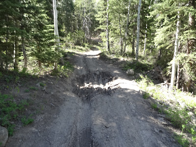
The Camelot has not been "worked over" by trail maintenance.  It is basically a single track kept alive by bikers.  No motorized are allowed.  It would be nice to have it re-worked into switchbacks to avoid the steep inclines.


Very pretty trail, peaceful and secluded

A meadow half way up the Camelot.


Once up the trail, we turned left onto the dirt road leading to Lake Hill.  We talked to the forest service guy in the truck.  He is surveying for a "timber sale", where they will take down quite a few of the large evergreens.  


"Lake Hill Reservoir".  We were able to access it to give the horses a drink.     Yay for water features!  


Representative of the dirt road just past where the Camelot Trail intersects.