Pages

Thursday, July 31, 2014

Ogden, Utah Rail Trail


This trail is accessed at 4000 N., 2000 W. just west of Smith and Edwards. Take exit 349 (Pleasant View-Far West). It makes a nice option when other trails are closed due to snow or mud. I thought it best for cooler weather riding or maybe early morning or evening to catch a sunset.  It can also be accessed from 6700 W, but it is closed from March 1 - September 1 WEST of 6700 W. for bird nesting season.  Dogs are allowed and can really get some exercise on this one.  We deemed the road a little too hard packed for cantering, but gaited horses could go lickety split and really cover the ground.

(Click on any photo to open enlarged images)


Mileage on this ride:  6.77; Min Altitude, 4,089; Ascent/Descent=470 ft; Trail conditions= 98% packed gravel road, 2% asphalt  (30% soft dirt trail if you choose to take that option.)
Hmmmmmm.  "Does that mean me?"


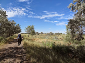
Heading out....there is a soft dirt trail beginning on the left side of this road.  We missed it on the way out, but rode it on the way back.


There are several gates, but they each have a "pass thru" easily negotiable on horseback.


The view of Ben Lomond from as far as we rode on this trip.


A little off-road action.

Looking east on the way back to the trail head.

We saw a lot of wildlife...geese, herons, doves, vultures, etc.

Part of the soft dirt trail available for the first mile out from the trail head.

Back to the parking area.


Wednesday, July 23, 2014

North Ogden, Canal Road-Bonneville Trail

  In spring and early summer, wildflowers abound.  Mid-summer is hot and dry with riding best in the early morning or late evening to catch a spectacular sunset.   Riding in the autumn provides some gorgeous color from the maples and oak. 
 Keep in mind that most of these trails go through private property and the land owners have allowed access and right of way for the Bonneville shoreline trail.  National forest doesn't begin until further up the hillside above the power lines.   Recommend parking at the equestrian park and riding along Mountain Rd. accessing through private property at 2200 N. Mountain Rd.  
The following photos were taken over many years and seasons.  Click on any photo for enlarged images.

(This trail now connects to a new portion which goes from "Pioneer" Trail up the mountain and crosses Coldwater Canyon.  The portion crossing Coldwater IS NOT RECOMMENDED  for horses.  There are portions of the trail that are extremely narrow with steep, unforgiving drop offs.  No place to pass safely or even dismount or turn around. You can ride up from Mountain Road access for about 2.5 miles until it begins its treacherous descent into Coldwater.  Recommend going back down the way you come up at that point.)

Spectacular view of Ben Lomond in the spring with Arrowleaf Balsamroot in the foreground.  Photo courtesy of Teisha Preece.


GPS tracks of one of our rides....Total mileage approximately 4.3 miles.  Trail conditions depend on which route you take.  You can ride 80% on hard packed gravel road or you can ride the upper trails, which include the Bonneville shoreline.  Trails are about 75% dirt, 25% rocky.
The lighter blue track shows where the ride may be extended to connect with the shoreline trail that comes out of the Nature Center trailhead.  I have never ridden all the way through because of the terrain and low hanging trees.  I have ridden the light blue track.  

View from part of the new Connector Trail in One Horse Canyon, March 2015

 New Connector Trail in One Horse Canyon, March 2015

View from the "Power Line" Trail  


Typical of the canal road where the canal is covered.


Typical of the canal road where the canal is uncovered.

Trail going up the hillside from the canal road, which connects to the shoreline trail.  

This is the same trail in the above photo, but in spring.  Photo courtesy of Tristan Nelson.

Typical of the shoreline trail in autumn.


Where the shoreline trail loops into Garner canyon. Going into Garner from the north has some low hanging branches.  We hope to get up there to do some trail maintenance.  There is also poison ivy right along the trail, so beware!  There is a wooden bridge.  
Just after crossing the bridge in Garner Canyon.


Just about to Steep Canyon.  This section of the trail used to be almost impassible by horseback, but it has been improved now to make it ride-able.

Switchback trail going north from Steep Canyon

Looking toward the north at the base of Steep Canyon


Riding the canal road in late November.


I call this the "Powerline" trail.  It basically just parallels the canal road, but higher up.  Lovely views and some places for cantering.


Riding the shoreline trail south after coming out of Garner Canyon.  Left of the sign is a trail that goes higher up heading south, but dead ends for horses.  The canyon there was at one time named Coldwater; locals also called it Garner, but Garner is actually the canyon just to the north.  There are two other Coldwater Canyons in the area, so it could be confusing.  I just call the canyon  "Steep".  But, to make it even more confusing, there is a cave up Steep Canyon that is called Garner Cave. 


Shoreline trail between Garner and Steep canyons.


Canal road looking at "Steep" Canyon.  Keep riding down to the right and it connects again with the shoreline trail that goes to the Ogden North Nature Center trailhead.

Heading back north on the canal road.


View of Ben Lomond looking north from the shoreline trail by the mouth of Garner Canyon (in the morning)


View of Ben Lomond looking north from the shoreline trail by the mouth of Garner Canyon (in the afternoon)


Sunset viewed from one of the "upper" trails looking down on Steep Canyon.
 From one of the "upper" trails looking down on Steep Canyon.

Sunset from the shoreline trail in mid-summer.

Monday, July 21, 2014

North Ogden, Coldwater Canyon

Here's another little known trail accessible from the Equestrian Park in North Ogden. Take a look at the other North Ogden trails for other options accessible from the Equestrian park.

Bonneville Shoreline

Pioneer Trail

Called Coldwater Canyon by the locals. (not to be confused with the Coldwater Canyon near Ogden Canyon.) Not marked at all.  This is a watershed canyon for some of North Ogden.
  It is steep, short and quite rocky, but has evergreens, ferns, poison ivy, stinging nettle and occasionally water features. 
The locals often hike here to "camp".  Higher up, it is National Forest.  And if followed through to the very top, would reach Lewis Peak. (though not easily) 
 The access passes through private land, so be considerate and close the gate at each pass through.
We ride this canyon maybe once every two years.  It's worth seeing once, but there are so many other places to ride.  I mostly just provided this post to inform people of what is up there.  It is one way to access the Bonneville Shoreline trail that crosses near the top.  (I have been told that the Bonneville trail access going south from Coldwater becomes extremely narrow and steep in spots.  My daughter runs this trail and says she wouldn't even take a bike on it, let alone a horse.)
The view riding up the road to reach the access.


Trail length up and back from arena= about 2.4 miles.  Minimum altitude=4,652 ft, maximum altitude=about 5,500 ft depending on how far up you go; Trail conditions=25% tight packed gravel road, 15% dirt and 60% rocks.


(Click on any photo for enlarged images.)


Turn "south" here.  This is private land and the owners have horses near.


Looking back at the equestrian park from the road.


Access gate...please be sure and close it after passing through.


Not sure what these buildings are for at the mouth of the canyon, but something to do with water treatment.


This tree was down in the trail.  The detour is to the right.


One of the water crossings with a little water actually in it.


Not a very clear photo, but it is showing some of the poison ivy that is abundant along the trail.  Beware, if taking a potty break!


The view from where there is a very rocky dry stream bed crossing.  On this ride, I didn't go further.  The Shoreline trail access crossing is about a hundred yards above this point.


Stinging nettle in the dry stream bed.  Beware again!


Often we venture up further past the rocky stream bed.  It is very pretty, but the trail becomes inaccessible for horses after about 1/4 mile. But, you can go either north or south on the Shoreline trail.  


Heading back down.


Showing one of the many "caps" on the springs.  All of the springs are "capped" with this particular one letting some water out.  In the left used to be a little meadow where we horse camped about 12 years ago.  Now, instead of grass, there is just houndstongue. (full of burrs). We have ridden up here in the past to gather elderberries, but since have found better sources.


Coming down the canyon with a view of the hillside full of gray rocks/gravel.


Approaching the first dry stream bed crossing.  If there weren't caps on the springs, this would be flowing year round.


Sunset at 8:45 pm on July 19, 2014.  Taken from the mouth of the canyon looking west.


View of North Ogden from the mouth of canyon.